19 resultater (0,26658 sekunder)

Mærke

Butik

Pris (EUR)

Nulstil filter

Produkter
Fra
Butikker

Visualizing cityscapes of Classical antiquity: from early modern reconstruction drawings to digital 3D models - Chiara Piccoli - Bog - Archaeopress -

Visualizing cityscapes of Classical antiquity: from early modern reconstruction drawings to digital 3D models - Chiara Piccoli - Bog - Archaeopress -

The amount of 3D modelling applications in archaeology has increased enourmously over the last decade. 3D recording techniques allow researchers to quickly and accurately document archaeological evidence, and 3D reconstructions have created new possibilities to communicate the results to a larger public. In this latter case, however, numerous scholars have expressed their concern regarding the ethics of such digital representations, since they give prominence to a crystallized image of the past and do not account for the complexity of the archaeological record. The study presented here aims to make a practical contribution to a new understanding and use of 3D reconstructions, namely as ‘laboratories’ to test hypotheses and visualize, evaluate and discuss alternative interpretations. In order to do so, an analysis of visual reconstructions of the early and late modern period is presented first, followed by a discussion of current applications of 3D digital reconstructions, with a special focus on cityscapes. Lastly, a practical implementation of a research-driven, intellectually transparent and GIS-based 3D reconstruction is proposed for the urban site of Koroneia, in Boeotia, Central Greece. Specifically, the methodology developed in this work uses tools that are employed in geo-design and modern urban planning in an innovative way, integrating GIS with a rule-based modelling approach. With a strong focus on the automation and iteration of the reconstruction process, our 3D visualization provides an intuitive insight into hidden relationships and associations among data, and allows the creation and evaluation of alternative reconstruction hypotheses.

DKK 701.00
1

Best Practices of GeoInformatic Technologies for the Mapping of Archaeolandscapes - - Bog - Archaeopress - Plusbog.dk

Wholesome Dwellings: Housing Need in Oxford and the Municipal Response, 1800-1939 - Malcolm Graham - Bog - Archaeopress - Booktok.dk

Wholesome Dwellings: Housing Need in Oxford and the Municipal Response, 1800-1939 - Malcolm Graham - Bog - Archaeopress - Booktok.dk

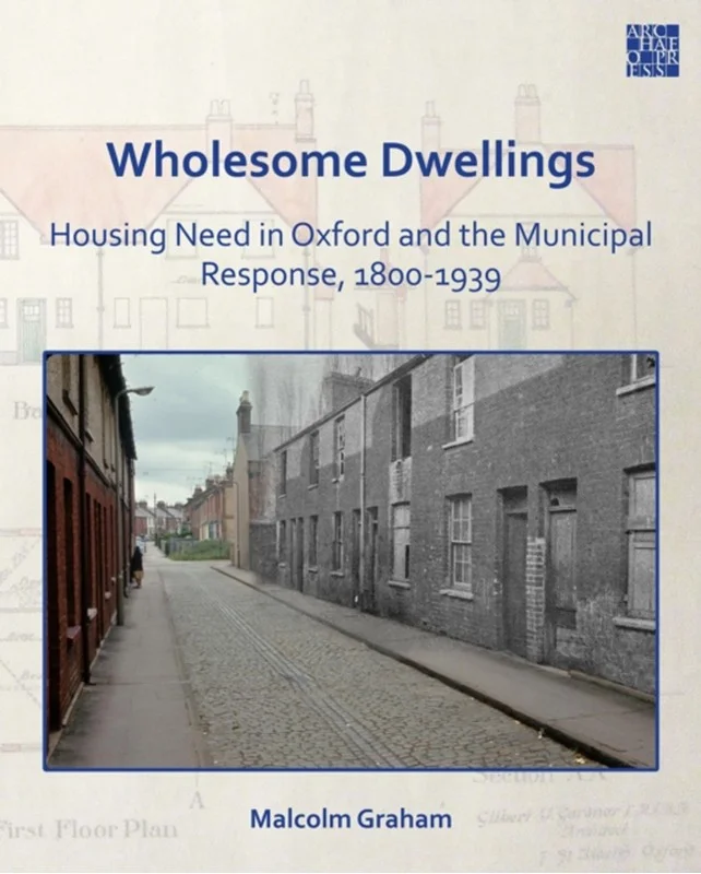
A shortage of affordable new housing, builders choosing to build larger, more profitable houses, and a diminishing stock of cheap houses for rent. All this sounds very familiar today, but at the end of the Great War, scarcely any houses had been built for four years and there was political pressure to build ‘Homes for Heroes’, impelled to a degree by fear of revolution. Council housing, supported by central government funding, was the chosen solution in 1919, and this study by Malcolm Graham, a leading Oxford local historian for many years, examines the consequences in Oxford, then a university city on the cusp of change. Behind the city’s Dreaming Spires image, housing for the working population was already in short supply, but an economy-minded and largely non-political City Council had always been reluctant to intervene in the housing market. In 1919, there was no hint of the city’s industrial future, and the City Council saw the replacement of substandard houses as its main challenge. The meteoric rise of the local motor industry in the early 1920s led to rapid population growth and created a massive new demand for cheap housing. Dr Graham examines the uneasy partnership between the City Council and Whitehall which led to the building of over 3,000 council houses in Oxford between the Wars. The provision of these ‘wholesome dwellings’ was a substantial, and lasting, achievement, but private builders were in fact catering for most housing need in and around the city by the 1930s. The notorious Cutteslowe Walls, built to exclude council tenants from an adjoining private estate, reflected the way in which the growing city was being socially segregated. Dr Graham provides a fascinating insight into how modern Oxford evolved away from the university buildings and college quadrangles for which the city is internationally renowned.

DKK 411.00
1

Approaches to the Analysis of Production Activity at Archaeological Sites - - Bog - Archaeopress - Plusbog.dk

Mapping Society: Settlement Structure in Later Bronze Age Ireland - Victoria Ruth Ginn - Bog - Archaeopress - Plusbog.dk

A Landscape of Conflict? Rural Fortifications in the Argolid (400–146 BC) - Anna Magdalena Blomley - Bog - Archaeopress - Plusbog.dk

A Landscape of Conflict? Rural Fortifications in the Argolid (400–146 BC) - Anna Magdalena Blomley - Bog - Archaeopress - Plusbog.dk

A Landscape of Conflict? Rural Fortifications in the Argolid (400–146 BC) is the first systematic study of Late Classical and Hellenistic rural fortifications in the territories of ancient Argos and the city-states of the Argolic Akte (northeastern Peloponnese). Based on one of the largest regional corpora of Greek fortified sites to date, the volume investigates the function of rural fortifications by placing them in the context of their surrounding landscape. This approach – combining ‘traditional’ methods of ancient history and landscape archaeology with GIS-based data analyses – helps to readdress the long-standing tension between ‘military-strategic’ and ‘non-military’ research agendas in Greek fortification studies, and highlights that Classical and Hellenistic rural fortifications are neither a priori fortified farmsteads nor parts of military-strategic networks of territorial defence. Instead, rural fortifications emerge in this monograph as multifunctional and multifaceted sites, which open a new window into different forms of ‘formal’ and ‘informal’ conflict in the ancient countryside and bear witness to a remarkable degree of local motivation and agency. The study thus demonstrates how ancient fortifications can provide an unexpected and so far much underappreciated opportunity for writing local or regional Greek histories – political and military as well as social and economic – from archaeological sources.

DKK 654.00
2

Assessing Iron Age Marsh-Forts - Shelagh Norton - Bog - Archaeopress - Plusbog.dk

Assessing Iron Age Marsh-Forts - Shelagh Norton - Bog - Archaeopress - Plusbog.dk

Iron Age marsh-forts are large, monumental structures located in low-lying waterscapes. Although they share chronological and architectural similarities with their hillfort counterparts, their locations suggest that they may have played a specific and alternative role in Iron Age society. Despite the availability of a rich palaeoenvironmental archive at many sites, little is known about these enigmatic structures, and until recently, the only acknowledged candidate was the unusual, dual-enclosure monument at Sutton Common, near Doncaster. Assessing Iron Age Marsh-Forts considers marsh-forts as a separate phenomenon within Iron Age society through an understanding of their landscape context and palaeoenvironmental development. At the national level, a range of Iron Age wetland monuments has been compared to Sutton Common to generate a gazetteer of potential marsh-forts. At the local level, a multi-disciplinary case-study is presented of the Berth marsh-fort in North Shropshire, incorporating GIS-based landscape modelling and multi-proxy palaeoenvironmental analysis (plant macrofossils, beetles and pollen).The results of both the gazetteer and the Berth case-study challenge the view that marsh-forts are simply a topographical phenomenon. These substantial Iron Age monuments appear to have been deliberately constructed to control areas of marginal wetland and may have played an important role in the ritual landscape.

DKK 451.00
1

Irish Late Iron Age Equestrian Equipment in its Insular and Continental Context - Rena (queen's University Belfast) Maguire - Bog - Archaeopress -

Irish Late Iron Age Equestrian Equipment in its Insular and Continental Context - Rena (queen's University Belfast) Maguire - Bog - Archaeopress -

Irish Late Iron Age Equestrian Equipment in its Insular and Continental Context is the first practical archaeological study of Irish Iron Age lorinery. The volume examines the bits and bosals (Y-pieces) holistically, using practical stable-yard knowledge merged with archaeological techniques such as morphometrics, use-wear, GIS, functional comparison to European and British equipment and distribution analysis to place it within its time and place. Irish Iron Age artefacts have always been beset by issues of chronology, but by using these various analytical methods, a more precise timeframe for the objects is indicated. A complex relationship with Roman Britain and the Empire also becomes visible, with aspects of identity and belief being expressed through the sophisticated equestrian equipment. The analysis of the bridle components reveal that the Ireland of the first centuries AD shares some characteristics with other boundary zones of the Roman Empire, such as Scotland and northern Germany, but also has its own unique interpretation of introduced technology. The Ireland of the Late Iron Age, then, is a society in flux, picking and choosing which traditions it maintains. The horse and associated equipment were very much at the heart of the social changes set in motion by contact with the Roman Empire, and as such, the examination of the snaffles and bosals allows us to bring the people of the Late Iron Age in Ireland into focus.

DKK 523.00
2

Physical Barriers, Cultural Connections: A Reconsideration of the Metal Flow at the Beginning of the Metal Age in the Alps - Laura Perucchetti - Bog -

Physical Barriers, Cultural Connections: A Reconsideration of the Metal Flow at the Beginning of the Metal Age in the Alps - Laura Perucchetti - Bog -

Physical Barriers, Cultural Connections: A Reconsideration of the Metal Flow at the Beginning of the Metal Age in the Alps considers the early copper and copper-alloy metallurgy of the entire Circum- Alpine region. It introduces a new approach to the interpretation of chemical composition data sets, which has been applied to a comprehensive regional database for the first time. An extensive use of GIS has been applied to investigate the role of topography in the distribution of metal and to undertake spatial and geostastical analysis that may highlight patterns of distribution of some specific key compositional element. The Circum-Alpine Chalcolithic and Early Bronze Age show some distinctively different patterns of metal use, which can be interpreted through changes in mining and social choices. But there are also some signs of continuity, in particular those which respect the use of major landscape features such as watersheds and river systems. Interestingly, the Alpine range does not act as a north-south barrier, as major differences in composition tend to appear on an east-west axis. Conversely, the river system seems to have a key role in the movement of metal. Geostastical analyses demonstrate the presence of a remelting process, applicable also in the case of ingots; evidence that opens new and interesting questions about the role of ingots and hoards in the distribution of metal at the beginning of the Metal Age. New tools and new analysis may also be useful to identify zones where there was a primary metal production and zones where metal was mostly received and heavily manipulated.

DKK 416.00
2

Hillforts: Britain, Ireland and the Nearer Continent - - Bog - Archaeopress - Plusbog.dk

Hillforts: Britain, Ireland and the Nearer Continent - - Bog - Archaeopress - Plusbog.dk

Funded by the AHRC, the Atlas of Hillforts of Britain and Ireland project (2012-2016) involved a team drawn from the Universities of Oxford, Edinburgh and Cork which was responsible for compiling a massive database, now freely available online at https://hillforts.arch.ox.ac, on hillforts in Britain and Ireland. This was underpinned by a major desk-based re-assessment of accessible records. These twelve studies, presented at the end of that exercise to a conference in Edinburgh, and contributed by team members and colleagues, outline the background to and development of the project (Gary Lock) and offer a preliminary assessment of the online digital Atlas (John Pouncett) as well as presenting initial research studies using Atlas data. The volume is profusely illustrated with over 140 figures, including many new maps. Ian Ralston provides a historical assessment of key stages in the enumeration and mapping of these important monuments on both sides of the Irish Sea. The hill- and promontory forts of England, Wales and the Isle of Man are assessed by Ian Brown and those of Ireland by James O’Driscoll, Alan Hawkes and William O’Brien. Stratford Halliday’s study of the Scottish evidence focuses on the impact of the application of the Atlas criteria to the records of forts in that country. Simon Maddison deploys Percolation Analysis as an example of the potential re-use of the Atlas data in analysing new distributions; Jessica Murray presents a GIS-based approach to hillfort settings and configurations. Syntheses on insular Early Historic fortified settlements in northern Britain and Ireland, by James O’Driscoll and Gordon Noble, and on hillforts in areas of the nearer Continent are included. The latter comprise an overview by Sophie Krausz on Iron Age fortifications in France and a consideration of the south German records of hillforts and oppida by Axel Posluschny, while Fernando Rodriguez del Cueto tackles the north-western Spanish evidence.

DKK 534.00
2

Proceedings of the Seminar for Arabian Studies Volume 40 2010 - - Bog - Archaeopress - Plusbog.dk

Proceedings of the Seminar for Arabian Studies Volume 40 2010 - - Bog - Archaeopress - Plusbog.dk

Volume Contents: The Qatar National Historic Environment Record: a bespoke cultural resource management tool and the wider implications for heritage management within the region (Rebecca Beardmore et al.); Preliminary pottery study: Murwab horizon in progress, ninth century AD, Qatar (Alexandrine Guérin); Excavations and survey at al-Ruwaydah, a late Islamic site in northern Qatar (Andrew Petersen & Tony Grey); Al-Zubārah and its hinterland, north Qatar: excavations and survey, spring 2009 (Alan Walmsley et al.); A possible Upper Palaeolithic and Early Holocene flint scatter at Ra''s Ushayriq, western Qatar (Faisal Abdulla Al-Naimi et al.); The dhow’s last redoubt? Vestiges of wooden boatbuilding traditions in Yemen (Dionisius A. Agius et al.); Building materials in South Arabian inscriptions: observations on some problems concerning the study of architectural lexicography (Alessio Agostini); Conflation of celestial and physical topographies in the Omani decorated mihrāb (Soumyen Bandyopadhyay); Al-Balīd ship timbers: preliminary overview and comparisons (Luca Belfioretti & Tom Vosmer); Fouilles à Masāfī-3 en 2009 (Émirat de Fujayrah, Émirats Arabes Unis): premières observations à propos d’un espace cultuel de l’Âge du Fer nouvellement découvert en Arabie orientale (Anne Benoist); First investigations at the Wādī al-Ayn tombs, Oman (poster) (Manfred Böhme); Glass bangles of al-Shīhr, Hadramawt (fourteenth–nineteenth centuries), a corpus of new data for the understanding of glass bangle manufacture in Yemen (Stéphanie Boulogne & Claire Hardy-Guilbert); L’emploi du bois dans l’architecture du Yémen antique (Christian Darles); Once more on the interpretation of mtl in Epigraphic South Arabian (a new expiatory inscription on irrigation from Kamna) (Serge A. Frantsouzoff); New evidence on the use of implements in al-Madām area, Sharjah, UAE (Alejandro Gallego López); The first three campaigns (2007-2009) of the survey at Ādam (Sultanate of Oman) (Jessica Giraud et al.); A new approach to central Omani prehistory (Reto Jagher & Christine Pümpin); Umm an-Nar settlement in the Wādī Andam (Sultanate of Oman) (Nasser al-Jahwari & Derek Kennet); Mapping Masna at Māryah: using GIS to reconstruct the development of a multi-period site in the highlands of Yemen (Krista Lewis et al.); Written Mahri, Mahri fusha and their implications for early historical Arabic (Samuel Liebhaber); How difficult is it to dedicate a statue? A new approach to some Sabaic inscriptions from Mahrib (Anne Multhoff); The semantic structure of motion verbs in the dialect of Zabīd (Yemen) (Samia Naïm); Preliminary results of the Dhofar archaeological survey (Lynne S. Newton & Juris Zarins); An early MIS3 wet phase at palaeolake Κaqabah: preliminary interpretation of the multi-proxy record (Ash Parton et al.); South Arabian inscriptions from the Farasān Islands (Saudi Arabia) (Solène Marion de Procé & Carl Phillips); The ‘River Aftan’: an old caravan/trade route along Wādī al-Sahbām (Nabiel Y. Al Shaikh & Claire Reeler); The Wādī Sūq pottery: a typological study of the pottery assemblage at Hili 8 (UAE) (Sabrina Righetti & Serge Cleuziou); A Βarf talisman from Ghayl Bā Wazīr, Hadramawt (Mikhail Rodionov); The Qalhāt Project: new research at the medieval harbour site of Qalhāt, Oman (2008) (Axelle Rougeulle); Irrigation management in pre-Islamic South Arabia according to the epigraphic evidence (Peter Stein); A detective story: emphatics in Mehri (Janet C.E. Watson & Alex Bellem); Shell mounds of the Farasān Islands, Saudi Arabia (M.G.M. Williams); The Almaqah temple of Meqaber Ga''ewa near Wuqro (Tigray, Ethiopia) (Pawel Wolf & Ulrike Nowotnick).

DKK 654.00
2